DISTANCE : 2700 miles approx. (4345 km)
START : Waterton Lakes National Park, US/Canada border.
FINISH : Columbus, New Mexico, US/Mexico Border.
MAPS / INFO :
- Jonathan Ley’s CDT Maps
- Jim Wolf CDTS guides
- DeLorme Atlas’ : Montana, Wyoming, Colorado and New Mexico.
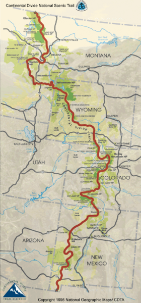
- Click here to see an overview map of the trail.
RESUPPLY :
- Combination maildrop (80%) and buy as I go (20%).
- Frequency of supply points is similar to the PCT; on average every 5 days.
ROUTE / CONDITIONS :
- Toughest of the Triple Crown trails from a navigational and logistical perspective.
- Not as established as the AT and PCT. Plenty of scope for alternative routes.
- I will be doing the CDT during the summer of 2012. Weather-wise I don’t forsee too many issues. Perhaps some afternoon electrical storms in the Rockies. Temperature-wise, things will be getting pretty hot in New Mexico; may carry a mylar-coated umbrella……….for purposes of shade rather than style…………not that sporting a parasol in the desert isn’t fashionable…………not sure how your average New Mexican rancher feels about the issue……..ramble, ramble……….
Discover more from The Hiking Life
Subscribe to get the latest posts sent to your email.