
Lake Oeschinen
Distance: 9.9 miles (16 km)
Avg.Time: 6 – 7 hours
Start / Finish:
- Griesalp – Kandersteg
- Griesalp can be reached by means of Switzerland’s excellent Post Bus system.
- Kandersteg is accessible either by bus or regular train services.
Season: June – October
Maps / Info:
- The hike is covered by two Topographic Maps: #264-1:50,000 Jungfrau and # 263-1:50,000 Wildstrubel.
- See the Via Alpina website for a basic map and altitude profile of the walk.
- The hike between Griesalp and Kandersteg is part of both the Swiss Alpine Pass Route and the Via Alpina, a 5000km + route which passes through 8 European countries and consists of a whopping 342 stages!
Route / Conditions:
- The trail is well marked and easy to follow from start to finish.
- This is a very popular route during the summer months; particularly on weekends and holidays. If you are hiking during this period, try to leave Griesalp as early as possible in order to avoid the crowds.
- For a relatively short hike, there is a great deal of altitude gain (1370m) and loss (1602m). The highest point of the walk is Hohturli (2778m).
- Fill your bottles up before leaving Bundalp (about one hour’s walk from Griesalp), as there isn’t much in the way of reliable water sources until you reach the stunning Oeschinensee.

Descending to the village of Kandersteg.
Sleeping:
- See the Via Alpina website for accommodation options in Griesalp and Kandersteg.
- For those wanting to overnight en route, there is accommodation available at the spectacularly set Blüemlisalp Hut.
Overview:
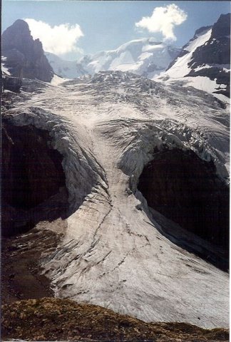
- Gorgeous alpine lakes, flower-filled meadows, snow-capped peaks, and glaciers.
- Griesalp to Kandersteg represents one of the most beautiful ten-mile stretches of hiking in the entire Swiss Alps.
Discover more from The Hiking Life
Subscribe to get the latest posts sent to your email.